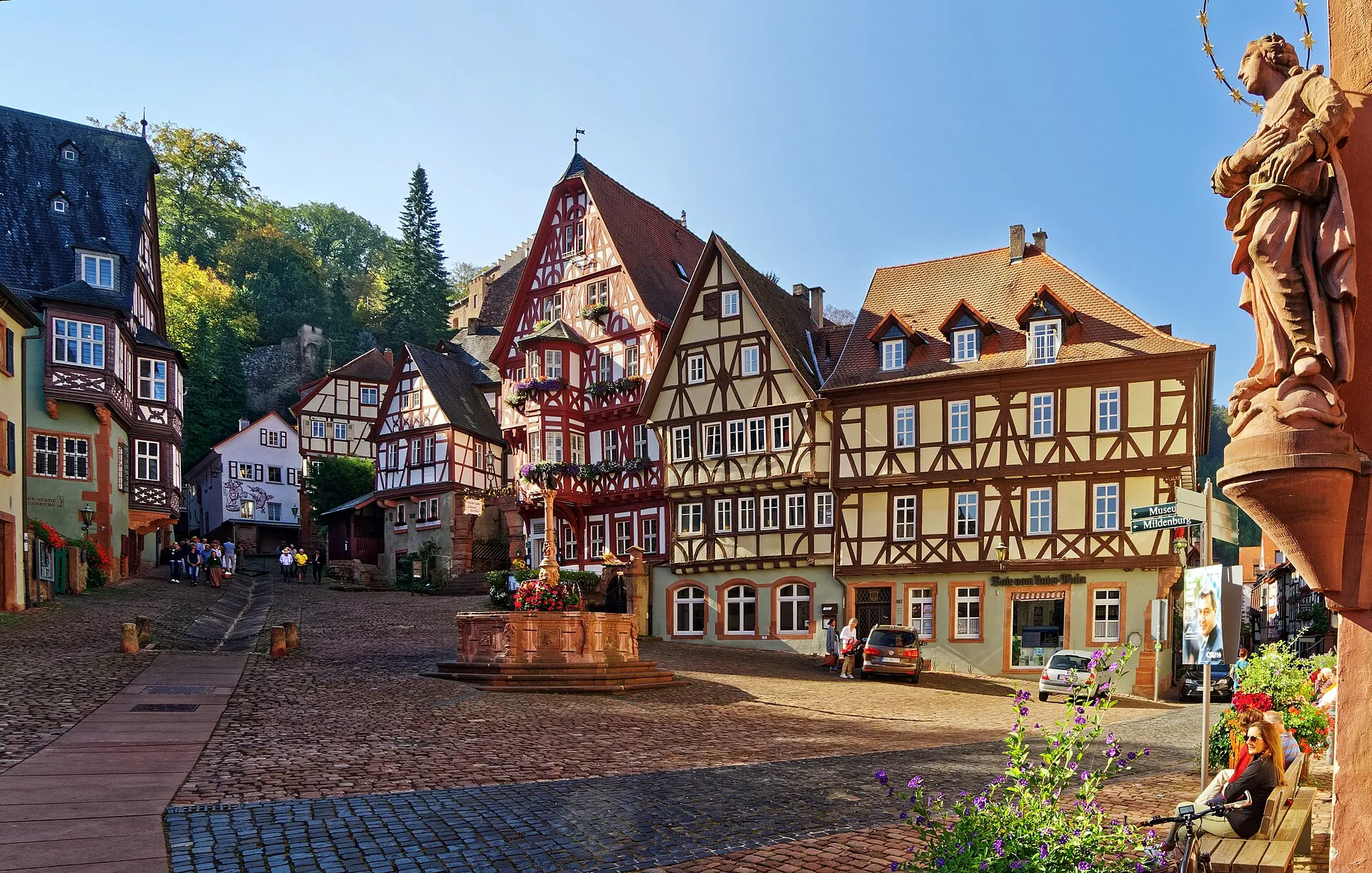
City portrait
Miltenberg – District Town on the Main Quadrangle
Miltenberg lies on the left bank at the bend of the Main quadrangle between the Spessart and the Odenwald, has belonged to Bavaria since 1816 and, together with neighbouring municipalities, counts over 22,000 inhabitants.
4.8(151)· GoogleAt a glance
History
At the bend of the Main between the Odenwald and Spessart, ring ramparts and Roman forts once guarded the narrow pass – later the Mildenburg, built from 1144, gave the town its name.
Already in pre- and early history people used the strategic setting of the narrow pass at the bend of the Main, building ring ramparts on the Greinberg and the Bürgstadter Berg. Around 159/160 AD the Romans connected the Vorderer Limes to the Main, which from here northward formed the border with Germania. The remains of two forts lie between Miltenberg and Kleinheubach and between Miltenberg and Bürgstadt. After the fall of the Limes by 259/260 AD at the latest they lost their function; coin finds show the Miltenberg-Altstadt fort was still inhabited in the 4th century. From the 7th, possibly the 6th century the ruins were used again in the course of the Frankish eastern colonisation, and in the 12th century a residential tower was built there.
The Mildenburg, which gave the town its name, was built from 1144 on land of Amorbach Abbey, according to research by Wolfgang Hartmann. The settlement that grew under the castle's protection is first documented in 1226 on the occasion of a visit by the Mainz Archbishop Siegfried II. From about 1379 the Mainz Gate and the Würzburg Gate bounded the long, narrow old town. Miltenberg sandstone was already sought after in the Middle Ages; the Heunen columns intended for the construction of Mainz Cathedral also came from Miltenberg.
Until 1803 Miltenberg belonged to Electoral Mainz and was seat of the Miltenberg district, recalled today by the Mainz wheel in the town's coat of arms. After the Reichsdeputationshauptschluss the town passed to the Principality of Leiningen, in 1806 to the Grand Duchy of Baden, from 1810 to Hesse-Darmstadt and finally in 1816 by treaty to the Kingdom of Bavaria; the municipal edict of 1818 established the present town. Jews are recorded in Miltenberg from the mid-13th century; in 1933, 99 Jewish people lived in the town, the last being deported in 1942. South of the town wall lies the Old Jewish Cemetery.
On 22 February 1945 six American fighter-bombers attacked the town, killing 20 people; the Main bridge was blown up by German troops on 28 March 1945, and US troops entered on 31 March. The Mildenburg has been owned by the town since 1979; after renovations and restoration work completed in 2011 it now houses the Museum Burg Miltenberg. As of 31 December 2024 the town had 9,351 inhabitants.
Location & geography
Miltenberg lies at the bend of the Main quadrangle between the Spessart and Odenwald, where the river runs close to the foot of the Odenwald.
Miltenberg is the administrative seat of the district of the same name in the governmental region of Lower Franconia and has belonged to the Kingdom of Bavaria since 1816. The present-day town centre and the historic core lie on the left bank of the Main, where the river forms the bend of the Main quadrangle between the ranges of the Spessart and the Odenwald.
Because the riverbed within the town's area moves close to the foot of the Odenwald, only a narrow strip of usable land remains on the left bank. Over past centuries this strip was repeatedly flooded by the Main, at times causing considerable damage to the old town. From roughly the beginning of the 20th century, following land purchases from the neighbouring municipality of Großheubach, Miltenberg also expanded onto the right bank of the river.
The town's elevation ranges from its lowest point in the Main at 120.5 m above sea level to its topographically highest point on the summit of the mountain "Kohlplatte" south of the town at 482 m above sea level. Miltenberg has somewhat over 9,300 inhabitants; together with the directly adjoining municipalities of Großheubach, Kleinheubach and Bürgstadt, the total exceeds 22,000.
The municipal area comprises eight constituent parts. The main town itself is divided spatially, though not politically, into several sections. The old town consists of the historic settlement core, which belongs to the Schwarzviertel, a first town extension reaching west to the Schwertfegertor and east to the Wamessertor, and a second town extension extending west to the Mainzer Tor and east to the Würzburger Tor.
Beyond the historic town walls, further sections adjoin in a clockwise direction. West of the Mainzer Tor lie the Monbrunn settlement on the near side of the Mud and Miltenberg-West on the far side of the small river. Across the old Main bridge, on the opposite bank, lies Miltenberg-Nord, which is split in two by the railway line and borders closely on the Großheubach industrial estate of Auweg. East of the Würzburger Tor and south of the Vögeleinstor stretches Miltenberg-Ost, which merges seamlessly in built-up form into the neighbouring municipality of Bürgstadt, complemented by the villa quarter on the Grauberg.
Within the municipal territory lie the cadastral districts of Breitendiel, Mainbullau, Miltenberg, Schippach/Mil and Wenschdorf. The Miltenberg cadastral district itself covers an area of 36.543 km² and is divided into 6,701 parcels with an average size of 5,453.30 m².
Culture & sights
From the Mildenburg to the historic marketplace with the „Schnatterloch" and one of Germany's oldest inns, Miltenberg is shaped by its architectural and archaeological monuments.
The heritage landscape of the town ranges from the Mildenburg above the settlement over the historic old town with its market square, colloquially called the „Schnatterloch", to a number of religious buildings. The recorded architectural and archaeological monuments include the Old Town Hall, the Würzburg and Mainz gates, the parish church of St. Jakobus and the Franciscan church. The Johanneskirche was built between 1895 and 1897 to plans by the architect Ludwig Hofmann. The Laurentius chapel with the adjoining Laurentius cemetery dates from the 14th century. South of the town wall lies the Old Jewish Cemetery, whose origins reach back into the Middle Ages.
The Mildenburg has been owned by the town of Miltenberg since 1979. The outer sections were renovated in 1971, and a restoration project spread over several years was completed in 2011. Today its interior houses the Museum Burg Miltenberg, which displays art collections of the Diocese of Würzburg. In the castle courtyard once stood the Toutonenstein, a five-metre-high sandstone column whose inscription remains undeciphered; it is now kept in the Museum Stadt Miltenberg.
Alongside the Museum Burg Miltenberg and the Museum Stadt Miltenberg there is the Apothekenmuseum Miltenberg. A further attraction is the Route der Industriekultur Rhein-Main, which over the 160 kilometres between Miltenberg and Bingen am Rhein links industrial structures into a route about the industrial age in southern Germany. Around 700 structures have been scientifically documented, among them the old Miltenberg main station.
The calendar of events is spread across several fixed dates. On the first weekend in July the „Mainfest" takes place every two years, having replaced the earlier old-town festival. At the end of July the „Mildenburger Theatertage" follow. From the last weekend in August to the first weekend in September the Michaelismesse lasts ten days and is regarded as the largest folk festival on the Bavarian Lower Main. From late September to early October the „Miltenberger Weinherbst" is held. On the four Advent weekends from Friday to Sunday the Christmas market is open.
Economy & infrastructure
Miltenberg relies mainly on tourism, the local red sandstone and trade – and is linked via the Main, used as a waterway since antiquity and now developed for large-scale shipping, where a peak of 681 cruise ships was counted in 2017.
The town's economy rests mainly on tourism, the local red sandstone and trade. In the Zukunftsatlas 2016 the district of Miltenberg ranked 197th of 402 and was placed among the regions with a balanced mix of opportunities and risks. Many residents find work in the Hessian conurbations to which Miltenberg is connected.
The main transport axis is the Main valley. The Main has served as a waterway since antiquity and is today developed for large-scale shipping; at two berths operated by the Stadtwerke EMB, over 500 river cruise ships docked in 2019, following a peak of 681 in 2017. Day-trip and sport boats also operate here. On the railway, Miltenberg is the junction of the line from Aschaffenburg opened in 1876 with the routes to Seckach and Wertheim put into service in 1880 and 1912; in 1977 the Deutsche Bundesbahn replaced the terminus close to the town with a through station located north of the Main.
Since 1900 a road bridge has linked the old town with Miltenberg Nord. In 2008 a bypass including the Martinsbrücke as a second bridge over the Main was completed; the 55-million-euro project was financed in Bavaria for the first time through a public-private partnership model. The federal road B 469 as well as several cycling and hiking trails run through the town, among them the Main Cycle Path and the Franconian Red Wine Trail.
Manufacturing includes the hygiene paper factory Fripa, whose waste heat supplies several schools through a local heating network and which received the Bund Naturschutz climate protection award in 2018. The Brauhaus Faust brewery exists in Miltenberg, while the Kalt-Loch-Bräu operated until the end of March 2010. Oswald Elektromotoren, founded in 1909, develops and produces motors here; Johannes and Bernhard Oswald received the German Environmental Award in 2017 for them. The local electricity and water supply is based at EMB Energieversorgung Miltenberg-Bürgstadt.
Politics
In the municipal election on 8 March 2026, the city council of Miltenberg was newly elected. Since the 1980s the city has maintained ties to other European countries.
Miltenberg is the administrative seat of the district of the same name in the administrative region of Lower Franconia and thus its district capital. The present district was formed on 1 July 1972, when the former district of Miltenberg merged with the district of Obernburg am Main. The town has belonged to Bavaria since 1816; before that it was part of Electoral Mainz until 1803 and served there as the seat of the Amt Miltenberg. This past is still recalled today by the Mainz wheel in the town's coat of arms.
The municipal representative body is the town council, which was newly determined in the local election. In addition to the council elections, Miltenberg also records the results of supra-local ballots, namely the federal, state and European elections. In these evaluations it should be noted that one of the listed parties still ran under the designation PDS until 2007.
At the head of the town stands the mayor. The history of the office includes a continuous list of the office holders, documenting the continuity of municipal leadership across the various political periods.
The town's ties to municipalities abroad hold a firm place in public life. Since 1982 a partnership has existed with the French municipality of Arnouville in the Île de France region. A second partnership has linked Miltenberg since 16 November 2004 with the Czech town of Duchcov in Bohemia.
This connection to Bohemia has a longer background: as early as 1960, Miltenberg assumed the sponsorship for the expelled Sudeten Germans from the town and district of Dux. From this sponsorship the formal town partnership with Duchcov developed in 2004, so that a bond originally arising from post-war history was transferred into a lasting municipal cooperation.
Miltenberg in numbers
Demographics, land use and politics — from official open data.
Miltenberg: age by sex (as of 31 Dec 2024).
Source: Regionalstatistik (Alter × Geschlecht) · tab. 12411-02-03-5
Miltenberg compared
Miltenberg compared with the municipalities in its district or the neighbouring towns — switch above. Tick areas — their values appear as coloured markers on the bars.
Tick areas — their values appear as coloured markers on the bars.
Structure
Source: Regionalstatistik
Land use (2015)
Economy
Education & family (per 10,000 pop.)
Source: OpenStreetMap · facility map
Health & retail (per 10,000 pop.)
Source: OpenStreetMap · facility map
Sport & leisure (per 10,000 pop.)
Source: OpenStreetMap · facility map
Tick areas — their values appear as coloured markers on the bars.
Political mood (federal election 23.02.2025)
Source: Federal Returning Officer · polling-district results, 2025 federal election
History in brief
- um 159/160 n. Chr.Romans connect the Vorderer Limes to the Main river near Miltenberg
- bis 259/260 n. Chr.Fall of the Limes, withdrawal of Roman troops, forts lose their function
- ab 1144Construction of Mildenburg castle on land owned by Amorbach Abbey
- 1226First documented mention of Miltenberg during a visit by the Archbishop of Mainz
- 1803End of Miltenberg's affiliation with the Electorate of Mainz
- 1818Founding of the current municipal community under the Bavarian Community Edict
- 1942Deportation of the last Jewish residents of Miltenberg
- 1945Bombing raid on the town and destruction of the Main bridge
Did you know?
Miltenberg's market square is popularly called 'Schnatterloch', and there is an ornamental fountain named Staffelbrunserbrunnen featuring three boy figures urinating water, named after a mocking nickname for the town's residents.
In the courtyard of Mildenburg castle once stood the Toutonenstein, a five-meter-high sandstone column whose inscription remains undeciphered to this day.
The famous Heunensäulen columns used to build Mainz Cathedral originated from Miltenberg; one of them still stands today on Mainz Cathedral square with an explanatory plaque.
Between 1803 and 1816, Miltenberg changed sovereign rule four times in rapid succession – from the Electorate of Mainz through the Principality of Leiningen and Baden to Hesse-Darmstadt, before finally becoming part of Bavaria in 1816.
On March 28, 1945, retreating German troops blew up the Main bridge without having closed it to traffic beforehand.
After the Thirty Years' War, Miltenberg's population of over 3,000 (in 1619) had roughly halved; the 3,000 mark was not exceeded again until the early 19th century.
Now explore the city
Sources & links
- Wikipedia (retrieved 2026-07-13)
- openstreetmap.org
How this page is made
This page draws on open sources — Wikipedia, Wikidata, official websites and the city’s open data. Every statement is checked against the sources linked here, and pages are refreshed regularly.
Spotted a mistake anyway? Tell us below — we read every submission.
Comments
- Loading comments…